Projects
INVESTORKIT
- Our Coal Product Offering
- October 2014 – Company Presentation
- Ulaan Ovoo summary
- Chandgana summary
- Bloomberg interview (China - click here) Aug 25, 2014
- Bloomberg in depth (25min) (Mongolia - click here) (China - click here) March 11, 2014
- Bloomberg interview (Mongolia - click here) (China - click here) Feb 26, 2014
- Bloomberg interview (China - click here) August 14, 2013


STOCKINFO
| TSX: PCY | 0.06 | -0.01 |
|---|---|---|
| OTC-QX: PRPCF | 0.0542 | -0.004 |
| Frankfurt: 1P2 | 0.049 | 0.00 |
Delayed by 20 minutes
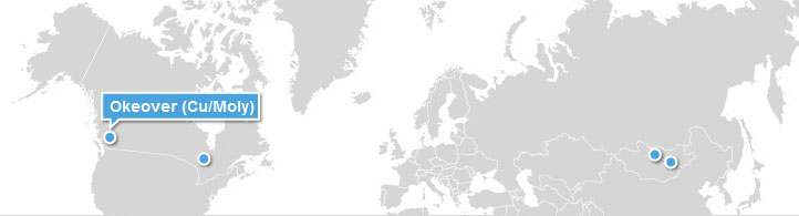
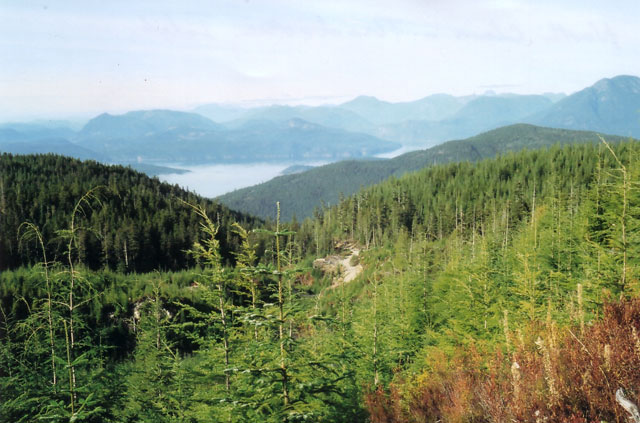
Okeover (Cu/Moly BC)
Location and Ownership
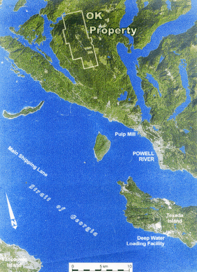
The Okeover Property (copper-molybdenum) consists of eleven contiguous legacy and cell mineral claims located in the Vancouver Mining Division of southwestern British Columbia, 25 kilometres north of Powell River and 145 kilometres northwest of Vancouver. Collectively, the claims cover an area of approximately 3,950 hectares between latitudes 49o59.5′ and 50o04.6′ North and longitudes 124o37.0′ and 124o41.2′
All claims are registered in the name of Eastfield and are subject to a March 4, 2003 option agreement with Robert Edward Mickle of Likely, B.C. whereby Eastfield has the right to earn a 100% interest in the property subject to a 2.5% net smelter royalty interest. This royalty interest may be purchased from the vendor for $2 million on commencement of commercial production. Cash payments to the vendor totaling $88,000 over a five year period are due at six month intervals in addition to the annual issuance of Eastfield securities amounting to 125,000 shares over the term of the agreement. The payments totaling $88,000 are payable by Prophecy pursuant to the terms of the agreement between Prophecy and Eastfield.
Goldrush, from whom the Company gained the right to earn an interest in the Okeover property via an assignment, entered into an agreement with Eastfield on March 8, 2004. Goldrush maintained the option in good standing through to March, 2006 at which time Goldrush assigned its interest in the option agreement to the Company in exchange for 100,000 shares of the Company and a $10,000 cash payment. At the same time the Company concluded a new agreement with Eastfield which provides the Company with the option to earn a 60% interest in the Okeover Property by making cash payments and/or stock issuances amounting to $110,000 to Eastfield over the next four years, plus incurring exploration expenditures totalling $1 million over the same period. Upon the Company earning its 60% interest in the Okeover property, the Company and Eastfield will form a joint venture for the further exploration and development of the Okeover property with Eastfield becoming the operator. To date, the Company has spent approximately $612,000 on exploration of the Okeover property and earned its 60% interest in the Okeover property.
Exploration Program
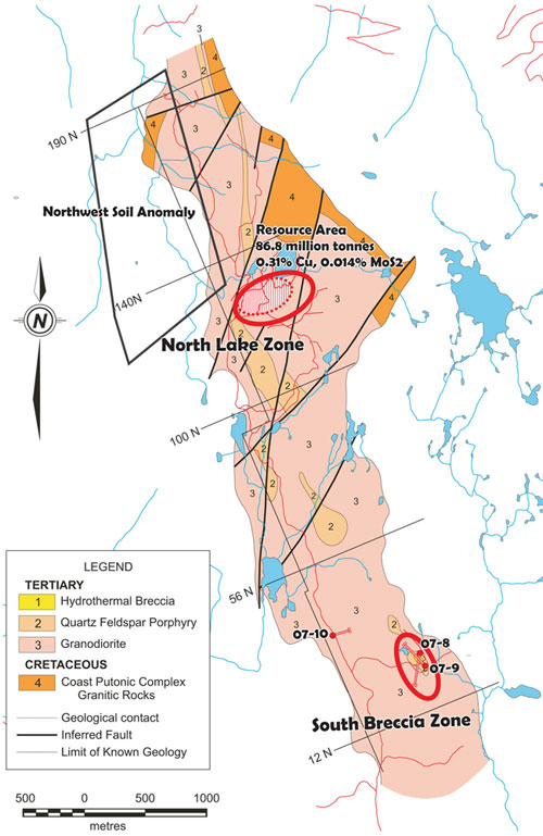
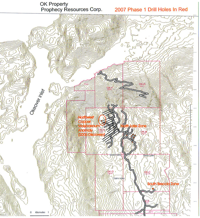
As recommended by N.C. Carter, the Company commenced a first phase program at Okeover in spring 2007 that included additional drilling of the North Lake Zone to expand upon the currently identified mineral resources.
In July, 2007 Prophecy received the results from the first four drill holes of a seven hole program recently completed at the Okeover copper-molybdenum property. The drill holes reported here were designed to expand the current resources of the North Lake Zone.
Hole OK-07-04, drilled near the western boundary of the North Lake Zone, intersected an aggregate intercept of 76 metres grading 0.34% copper and 0.020% MoS2, including an intercept of 19 metres grading 0.42% copper and 0.020% MoS2. Hole OK-07-04 was drilled adjacent to and beneath a hole completed in 1972 with much of the mineralized interval, including the higher grade section, occurring beneath the 1972 hole, which bottomed at a depth of 97 metres.
Hole OK-07-02, drilled 350 metres to the east of the area corresponding to the North Lake resource, intersected 23 metres grading 0.24% copper and 0.031% MoS2 at the bottom of the hole, establishing that mineralization is very much open ended to the east and suggesting that the North Lake Zone may be considerably larger than the 2006 estimate. In addition, molybdenum grades appear to be increasing to the east.
A summary of results of the first four holes is as follows:
Hole OK-07-01
Excluding several internally dilutive dykes greater than 4 metres in thickness:
| Beginning | Ending | Aggregate Mineralization | Copper (%) | MoS2 (%) |
|---|---|---|---|---|
| 29 m | 203 m | 147 m | 0.18 | 0.009 |
Mineralized intervals in OK-07-01 in detail
| From (m) | To (m) | Interval (m) | Copper (%) | MoS2 (%) |
|---|---|---|---|---|
| 29 | 47 | 18 | 0.16 | 0.010 |
| 56 | 90 | 34 | 0.17 | 0.008 |
| 92 | 132 | 40 | 0.17 | 0.009 |
| 138 | 166 | 28 | 0.17 | 0.007 |
| 171 | 191 | 20 | 0.24 | 0.010 |
| 196 | 203 (end) | 7 | 0.19 | 0.019 |
OK-07-01 is located approximately 75 metres to the east of the 2006 North Lake Zone (south side).
Hole OK-07-02
| From (m) | To (m) | Interval (m) | Copper (%) | MoS2 (%) |
|---|---|---|---|---|
| 165 | 188 (end) | 23 | 0.24 | 0.031 |
OK-07-02 is located approximately 350 metres to the east of the 2006 North Lake Zone.
Hole OK-07-03
Excluding several internally dilutive dykes greater than 4 metres in thickness:
| Beginning | Ending | Aggregate Mineralization |
Copper (%) | MoS2 (%) |
|---|---|---|---|---|
| 73 m | 188 m | 75 m | 0.19 | 0.029 |
Mineralized intervals in OK-07-03 in detail
| From (m) | To (m) | Interval (m) | Copper (%) | MoS2 (%) |
|---|---|---|---|---|
| 73 | 116 | 43 | 0.17 | 0.031 |
| 123 | 135 | 12 | 0.17 | 0.020 |
| 151 | 156 | 6 | 0.27 | 0.032 |
| 160 | 170 | 10 | 0.27 | 0.030 |
| 176 | 179 | 3 | 0.24 | 0.020 |
| 187 | 188 (end) | 1 | 0.19 | 0.028 |
OK-07-03 is located approximately 50 metres to the east of the North Lake Zone (north side). The interval from 73.7 metres to 74.5 metres returned grades of 1.26% copper and 0.639% MoS2.
Hole OK-07-04
Excluding several internally dilutive dykes greater than 4 metres in thickness:
| Beginning | Ending | Aggregate Mineralization |
Copper (%) | MoS2 (%) |
|---|---|---|---|---|
| 41 m | 141 m | 76 m | 0.34 | 0.020 |
Mineralized intervals in OK-07-04 in detail
| From (m) | To (m) | Interval (m) | Copper (%) | MoS2 (%) |
|---|---|---|---|---|
| 41 | 61 | 20 | 0.35 | 0.029 |
| 72 | 91 | 19 | 0.42 | 0.027 |
| 104 | 141 | 37 | 0.29 | 0.012 |
OK-07-04 is located near the western boundary of the North Lake Zone, adjacent to and underneath a hole drilled in 1972, hole 72-16, which bottomed at 97 metres.
Holes OK-07-01 to 04 have confirmed that mineralization in the North Lake Zone has not been constrained by depth and remains open on the eastern and western edges, offering substantial opportunities for expansion of the resource.
South Breccia Zone, Winter 2007
The final drill program of 2007, which started in late October, was completed on December 15, 2007. This three hole drill program was designed to test the South Breccia Zone located 3,500 metres south of the North Lake Zone.
At the South Breccia Zone, well altered and locally highly mineralized exposures of hydrothermal breccia and silicified quartz diorite were previously identified but, until now, have had very little exploration. Three holes were completed totalling approximately 790 metres (2,600 feet). Both the first and second holes completed during the program returned large footages with visible chalcopyrite and molybdenite mineralization.
 |
 |
History
Copper and molybdenum mineralization was discovered in creek bottoms in the central part of on the Okeover Property by the current registered owner in 1965. Between 1966 and 1977, seven companies carried out a number of geological, geochemical and geophysical surveys, mechanical trenching and more than 14,000 metres of drilling. Companies working on the property included Noranda Exploration Company Ltd., Asarco Exploration Company of Canada Limited, Falconbridge Nickel Mines Ltd., Duval International Corporation, Granite Mountain Mines Ltd., Sierra Empire and Western Mines Ltd.
Drilling completed between 1966 and 1977 consisted of 13,831.5 metres of diamond drilling in 82 holes and 12 vertical percussion holes totalling 732 metres. Most of the diamond drill holes were inclined at - 45° or less and five were vertical holes. Average hole length was 169 metres and the deepest hole drilled was 363 metres in length. Average vertical depth tested was between 120 and 140 metres below surface. Vertical percussion holes were drilled to 61 metres depths. Readily available reports pertaining to drilling include only those of Western Mines Ltd. in 1974 and 1977. Original drill logs and analytical results for core and cuttings samples from all holes drilled between 1966 and 1977 were digitized in the late 1980s and these data were acquired on behalf of Goldrush in late 2004.
Work included limited diamond drilling (3 holes totalling 205 metres), geological mapping, an Induced Polarization geophysical survey and soil geochemical surveys, road building and trenching.
CanQuest Resource Corporation acquired the rights to the property in the early 1990s and a reconnaissance geological mapping and sampling program was undertaken in the area of the southern breccia zone in 1994. A small grid (4.2 line kilometres) was established in 1995 to cover this area in the south-central part of the Okeover C mineral claim and an Induced Polarization survey was completed. An area of higher chargeability identified by this survey was tested by one short (154 metres) inclined diamond drill hole in 1996. Follow-up work in 1997 included mapping of bedrock exposed in newly constructed logging roads. An expanded program in 1998 consisted of geological mapping and bedrock chip sampling in other areas of the property plus limited soil geochemical sampling and orientation magnetometer, VLF-EM and Self Potential geophysical surveys in selected areas.
A geological mapping, prospecting and bedrock sampling program on the Okeover Property was undertaken by Mincord Exploration Consultants Ltd. on behalf of Lumina Copper Corp. in October of 2003. This work, which was mainly directed to bedrock exposures along logging roads in the central southern property area, included geological mapping at 1:5000 scale, petrographic studies and the collection and subsequent analyses of 81 rock samples. Total cost of this program was $31,509.
An airborne geophysical survey over a large part of the property was completed between July 12 and 15, 2004 by Fugro Airborne Surveys Corp. on behalf of Goldrush. This survey, conducted by helicopter, involved the collection of electromagnetic, resistivity and magnetic data. Program costs were in the order of $82,000. Goldrush also funded a six hole, 975 metres diamond drilling program in 2005 which cost approximately $175,000 to complete.
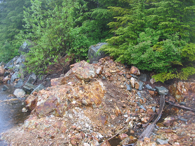
A surface exploration program was completed on the Okeover Property by the Company over a five week period between late May and late June of 2006. As an adjunct to the geochemical programs undertaken, a large excavator was used to improve road access within and marginal to the North Lake Zone. This work involved the extension of existing roads and construction of several drill pads east of 05-01, 05-03 and 05-05 drill holes completed in 2005. A number of grab samples were collected from bedrock exposed along the newly constructed roads. Chalcopyrite and molybdenite were found in quartz stockwork cutting quartz diorite between newly constructed drill pads east of hole 05-3.
Sites of 1960’s drilling in the Claim Lake Zone were located and a road route into this area was investigated.
Some investigation and bedrock sampling was also undertaken in several areas in the northern and southern parts of the property during the 2006 program. Further examination of the Breccia Zone suggests that it forms the core of a wider zone of silicification, minor brecciation and moderate quartz stockwork development hosting variable chalcopyrite and molybdenite mineralization.
The two new soil grids were established. The northernmost grid area, which is immediately northwest of the North Lake Zone, was selected following a review of 2004 airborne geophysical data which had identified geophysical responses similar to those underlying the North Lake Zone. These included a relatively low magnetic response and generally coincident high resistivity readings. A flagged grid consisting of 15 lines at roughly 100 metres intervals was established off part of the original survey baseline. A total of 499 soil samples were collected at 25 metres intervals along the flagged lines and submitted to Acme Analytical Laboratories in Vancouver for 4-acid digestion and the subsequent determination of 35 major and trace elements (including copper and molybdenum) by ICP — emission spectrography procedures.
Enhanced copper and molybdenum values were found throughout the grid area with the highest values being 1244 ppm (parts per million) copper and 534 ppm molybdenum. A previous statistical analysis of soil sample results from the Okeover Property suggested that anomalous values were >260 ppm copper and >27 ppm molybdenum. Assuming these values to be applicable to the results obtained from the 2006 program, less than 20 samples contain what might be referred to as anomalous values. Significantly, several of these are near the western limits of the sample grid. Molybdenum on the other hand features a much broader distribution of “anomalous” values with some 90 samples collected throughout the grid area containing values in excess of 27 ppm.
A smaller grid, consisting of three flagged lines at 100 metres spacings, was established to further assess the potential of the Southwest Zone situated southwest of the Breccia Zone. Ninety-nine soil samples, collected at 25 metres intervals, returned only slightly enhanced copper and molybdenum values with the highest values being 115 ppm copper and 52 ppm molybdenum.
Resource
- Find out more about Okeover Property’s Summary of Mineral Resources … Read More >>
Cautionary Note Regarding Forward-Looking Statements
Certain statements contained on this page, including statements which may contain words such as “expects”, “anticipates”, “intends”, “plans”, “believes”, “estimates”, or similar expressions, and statements related to matters which are not historical facts, are forward-looking information within the meaning of applicable securities laws. Such forward-looking statements, which reflect management’s expectations regarding Prophecy’s future growth, results of operations, performance, business prospects and opportunities, are based on certain factors and assumptions and involve known and unknown risks and uncertainties which may cause the actual results, performance, or achievements to be materially different from future results, performance, or achievements expressed or implied by such forward-looking statements. These estimates and assumptions are inherently subject to significant business, economic, competitive and other uncertainties and contingencies, many of which, with respect to future events, are subject to change and could cause actual results to differ materially from those expressed or implied in any forward-looking statements made by Prophecy.
In making forward-looking statements as may be included on this page, Prophecy has made several assumptions that it believes are appropriate, including, but not limited to assumptions that:; there being no significant disruptions affecting operations, such as due to labour disruptions; currency exchange rates being approximately consistent with current levels; certain price assumptions for coal, prices for and availability of fuel, parts and equipment and other key supplies remain consistent with current levels; production forecasts meeting expectations; the accuracy of Prophecy’s current mineral resource estimates; labour and materials costs increasing on a basis consistent with Prophecy’s current expectations; and that any additional required financing will be available on reasonable terms. Prophecy cannot assure you that any of these assumptions will prove to be correct.
Numerous factors could cause Prophecy’s actual results to differ materially from those expressed or implied in the forward looking statements, including the following risks and uncertainties, which are discussed in greater detail under the heading “Risk Factors” in Prophecy’s most recent Management Discussion and Analysis and Annual Information Form as filed on SEDAR and posted on Prophecy’s website: Prophecy’s history of net losses and lack of foreseeable cash flow; exploration, development and production risks, including risks related to the development of Prophecy’s Ulaan Ovoo coal property; Prophecy not having a history of profitable mineral production; the uncertainty of mineral resource and mineral reserve estimates; the capital and operating costs required to bring Prophecy’s projects into production and the resulting economic returns from its projects; foreign operations and political conditions, including the legal and political risks of operating in Mongolia, which is a developing jurisdiction; title to Prophecy’s mineral properties; environmental risks; the competitive nature of the mining business; lack of infrastructure; Prophecy’s reliance on key personnel; uninsured risks; commodity price fluctuations; reliance on contractors; Prophecy’s minority interest in Prophecy Platinum Ltd.; Prophecy’s need for substantial additional funding and the risk of not securing such funding on reasonable terms or at all; foreign exchange risks; anti-corruption legislation; recent global financial conditions; the payment of dividends; and conflicts of interest.
These factors should be considered carefully, and readers should not place undue reliance on the Prophecy’s forward-looking statements. Prophecy believes that the expectations reflected in the forward-
looking statements contained on this page and the documents incorporated by reference herein are reasonable, but no assurance can be given that these expectations will prove to be correct. In addition, although Prophecy has attempted to identify important factors that could cause actual actions, events or results to differ materially from those described in forward looking statements, there may be other factors that cause actions, events or results not to be as anticipated, estimated or intended. Prophecy undertakes no obligation to release publicly any future revisions to forward-looking statements to reflect events or circumstances after the date when information on this page is published or to reflect the occurrence of unanticipated events, except as expressly required by law.